Developments
MONTURQUE, Córdoba
Monturque Industrial Estate
- Sorroundings/Situation
- Gallery of Images
- Plans
- Virtual images
- More information
Sorroundings/Situation
Sorroundings/Situation
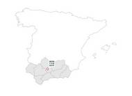
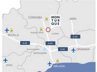
The village of Monturque is to the far south of the Cordoba countryside, more specifically in farming county called Campiña Alta, inside the Genil Valley although the eastern limits are closer to the foothills of the mountains of Lucena and Cabra, 61 km. To the south of the capital of the province and at 395 m. above sea level, it is well communicated through an important network of roads and is in the geographical centre of Andalusia. It is 12 kilometres away from Lucena, the main town in the province in terms of population and wealth, after the capital.
The Mediterranean climate offers no differences from what would be expected from these surroundings. Temperatures in summer are high and the winters are warm, although can be affected by fronts from the continental mass. The rain, between 500 and 550 mm. a year, usually come from the west, although we can also suffer the effects of being so near to the mountain ranges of the Sierras Subbéticas.
To get to the town centre, take the N-331 direction Cordoba-Malaga, in some stretches it becomes the A-45 Dual Carriageway, following the exit marked "Monturque y Cabra", or the other marked "Aguilar Sur y Puente Genil, and then follow directions towards Monturque.
The town is typical of the old fortress-towns, with the castle at the top of the mountain and the houses flowing down its sides. There are two types of streets: some follow the curves of the mountain and others cross them creating some occasionally quite impressive slopes.


